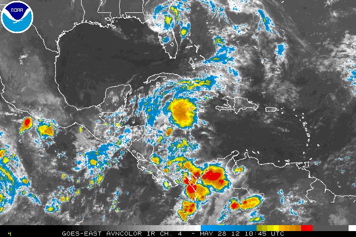
Feature(s) of Interest:
Two systems were responsible for the outbreaks of showers and thunderstorms last week and over the weekend. The first was a persistent low pressure area over and just offshore Belize that eventually drifted NE towards Cuba by late Wednesday. While, in the upper atmosphere, a westward drifting short-wave trough moved over Belize on Sunday and its axis now extends from NW Bahamas south-westward across the eastern Gulf of Mexico and central Yucatan Peninsula and Guatemala. This feature is forecast to continue its westwards displacement as an upper anticyclone migrates westward over northern Central America by Thursday of this week.
A weak tropical wave will make its way westward over the central and western Caribbean this week, reaching the Yucatan and Belize coasts by late Wednesday. Otherwise, the airflow in the NW Caribbean will become drier in a weak SE’ly current as we approach the weekend. Showers may likely be on the increase once again on Sunday afternoon and Monday.
Daily rainfall accumulations will be in the range of 0.25-0.50 of-an-inch over north-western and northern Belize on Monday, Tuesday and Wednesday of this week, with amounts of 0.50-0.75 of-an-inch in the higher terrain and some parts of the coast. Daily accumulations will decrease on Thursday through most of the weekend over the country as the airflow becomes drier and more stable. We can expect daily totals of 0.10-0.25 of an inch especially in the N and NW regions.


Tropical Cyclone Outlook:
The models are not forecasting any tropical cyclone formation over the Caribbean during the next five days.


Belize Five-day Outlook for Agriculture and Industry…
| Mon | Tue | Wed | Thu | Fri | Sat | Sunday |
|---|---|---|---|---|---|---|
| May 28, 2012 | May 29, 2012 | May 30, 2012 | May 31, 2012 | June 1, 2012 | June 2, 2012 | June 3, 2012 |
| Cloudy with sunny spells. A few showers & thunderstorms.
Rainfall: 0.25-0.50 of-an-inch |
Sunny with cloudy spells. A few showers & thunderstorms.
Rainfall: 0.25-0.50 of-an-inch |
Sunny with cloudy spells. Few moderate showers.
Rainfall: 0.50-0.75 of-an-inch |
Sunny with cloudy spells. Few moderate showers.
Rainfall: 0.25-0.50 inch |
Mostly sunny with isolated showers.
Rainfall: 0.10-0.25 of-an- inch |
Mostly sunny with isolated showers.
Rainfall: 0.10-0.25 of-an-inch |
Sunny with cloudy spells. Few moderate showers.
Rainfall: 0.25-0.50 inch |
Monday
May 28, 2012
RFrutos, Agrometeorologist/Hydrologist


