Valid Time: May 14 – May 21, 2012
Issued: 9:00 pm Sunday, May 13, 2012
Feature(s) of Interest:
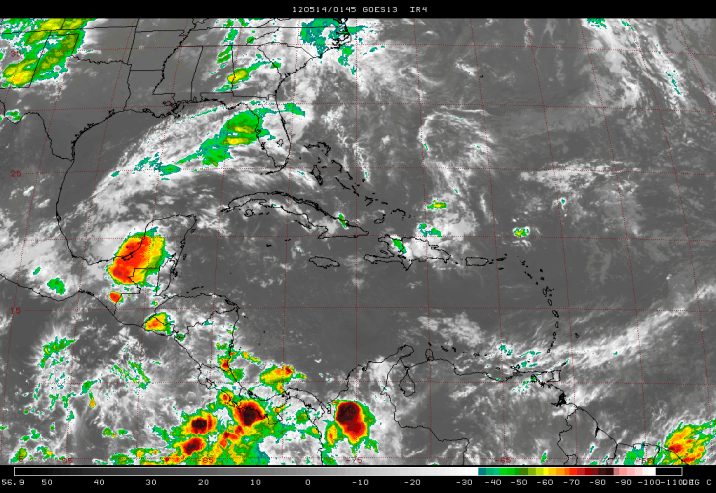
A quasi-stationary front over the Louisiana Gulf Coast to the central Gulf of Mexico has an induced surface trough of low pressure over the Yucatan Peninsula. These features together with a divergent SW’ly airstream from the Pacific aloft, have been generating outbreaks of thunderstorms and showers over Campeche, El Peten and western and southern Belize over the past 24-36 hours.
Analysis of the upper level weather charts show that the winter-time westerlies have now become disrupted over the subtropics, which is indicating a return to a summer pattern and the gradual onset of the 2012 rainy season. The GFS model projections of stability indices, surface pressure pattern and low level winds for the next five to seven days points to an increase in moisture and instability in the NW Caribbean and over northern Central America, as a surface low pressure system tries to become organized this week, and evolves into the first weak disturbance for the season just over and offshore Belize. The low will remain stationary just offshore central Belize on Thursday, and will then begin to track NNE into the eastern Gulf of Mexico during the coming weekend. Cloudy and unsettled weather will therefore persist over Belize during most of this week, with showers and thunderstorms becoming more persistent on Thursday through Monday of next week. This could mark the beginning of the rainy season for Belize. However, it is likely that the onset of the rains will be gradual in most places as we move towards June, but yes, the transition to a rainy season airflow pattern is almost completed as we should see more rainy days over the next seven to ten days.
Daily rainfall accumulations will be in the range of 0.10-0.25 of-an-inch over western and southern areas on Monday, Tuesday and Wednesday of this week, with amounts of 0.50-0.75 of-an-inch along the coast. Daily accumulations of 1.25-2.00 inches are likely, especially along the coast and the central highlands as the surface low forms and deepen just over and offshore the central coast of Belize by late Wednesday and Thursday.


Belize Five-day Outlook for Agriculture and Industry…
| Mon | Tue | Wed | Thu | Fri | Sat | Sunday |
| May 14, 2012 | May 15, 2012 | May 16, 2012 | May 17, 2012 | May 18, 2012 | May 19, 2012 | May 20, 2012 |
| Cloudy with sunny spells. Outbreaks of moderate showers and thunderstorms.
Rainfall: 0.25-0.50 of-an-inch |
Cloudy with sunny spells. Outbreaks of moderate showers and thunderstorms.
Rainfall: 0.25-0.50 of-an-inch |
Cloudy with sunny spells. Outbreaks of moderate showers and thunderstorms.
Rainfall: 0.50-0.75 of-an-inch |
Cloudy with outbreaks of showers and thunderstorms, especially over the coast & sea.
Rainfall: 1.50-1.75 inch |
Cloudy with outbreaks of showers and thunderstorms, especially over the coast & sea.
Rainfall: 0.75-1.00 inch
|
Cloudy with outbreaks of showers and thunderstorms, especially over the coast, hills and South.
Rainfall: 0.75-1.00 inch |
Cloudy with outbreaks of showers and thunderstorms over most places
Rainfall: 0.75-1.00 inch |
Monday
May 14, 2012
RFrutos, Agrometeorologist/Hydrologist


