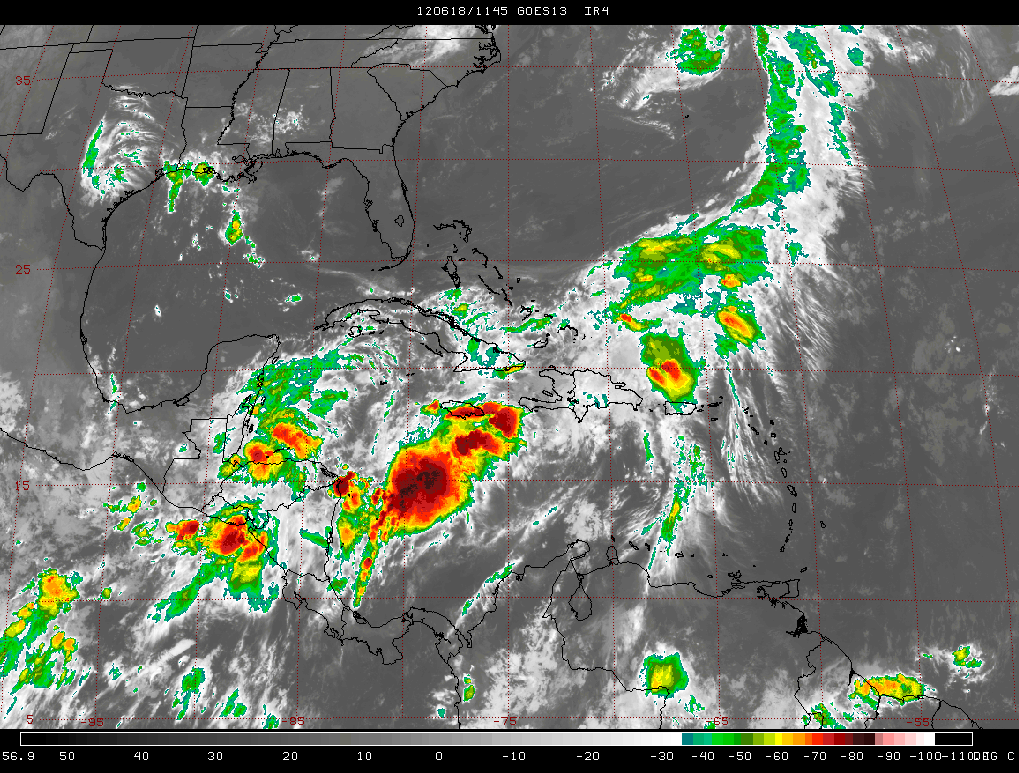
PERIOD: Sunday, June 17 until Monday, June 25, 2012
DATE ISSUED: Sunday, June 17, 2012; 3:00 pm
SYNOPSIS: An upper level trough swinging eastwards from the Gulf of Mexico is interacting with a trough of low pressure over the NW Caribbean. This atmospheric pattern will persist until Wednesday, favoring more showers. Meanwhile, a surface low will move over Belize and Yucatan during the next 48-72 hours, generating more showers and thunderstorms over most districts this week.

Substantial influx of moisture was forced northward ahead of an upper level trough moving slowly eastward from the Gulf of Mexico and a surface trough of low pressure extending from the Bahamas to the NW Caribbean. This resulted in heavy and widespread showers and thunderstorms across Belize this weekend, generating localized floods. Satellite imagery revealed that the bulk of the rainfall was concentrated over southern districts and the coast. Rainfall total in the range of six (6) inches was accumulated at the International Airport over the weekend. Other localities in the South accumulated in excess of six inches over the weekend.
During this week we can expect the showery weather to persist. A surface low is moving slowly WNW towards Belize from just offshore NE Honduras. This low will cross Belize late Wednesday and will move over northern Yucatan and the southern Gulf of Mexico by Thursday and Friday.
Daily rainfall accumulations will range from 0.50-1.50 inches on Sunday through Wednesday over most districts, but will increase to 1.00-2.00 inches per day on Thursday through Saturday, mostly over central and northern areas. Daily rainfall totals on Sunday through Monday will be ranging from 0.50-1.25 inches, especially over the central and NE areas of the sea and the mainland. Expect higher rainfall in the higher terrain this week.
Belize Seven-day Outlook for Agriculture and Industry…
| Sun | Mon | Tue | Wed | Thu | Fri | Sat |
|---|---|---|---|---|---|---|
| June 17, 2012 | June 18, 2012 | June 19, 2012 | June 20, 2012 | June 21, 2012 | June 22, 2012 | June 23, 2012 |
| Cloudy with outbreaks of showers & thunderstorms
mostly central & southern areas. Rainfall: 0.50-1.00 inches |
Cloudy with more outbreaks of showers & thunderstorms
mostly in the central & southern areas. Rainfall: 0.50-1.50 inches |
Cloudy with scattered showers & thunderstorms over most districts and coastal waters…
Rainfall: 0.50 – 1.50 inches |
Cloudy with outbreaks of showers & thunderstorms increasing mostly north-west and central areas.
Rainfall: 1.00 – 2.00 inches |
Cloudy with more out-breaks of showers & thunderstorms
mostly over central & northern areas. Rainfall: 1.25 – 2.50 inches |
Cloudy with a few showers & thunderstorms mostly the NW sector of the interior and the coast.
Rainfall: 0.75-1.50 inches |
Cloudy with a few showers & thunderstorms mostly over NW sector of the mainland.
Rainfall: 0.50-1.50 inches |


Outlook for the Main Development Region (MDR) of the Tropical Atlantic Basin
Tropical Weather Outlook
NWS National Hurricane Center, Miami, FL.
For the North Atlantic… Caribbean Sea and the Gulf of Mexico
1. A WELL-DEFINED NON-TROPICAL AREA OF LOW PRESSURE LOCATED ABOUT 300 MILES NORTHEAST OF BERMUDA IS PRODUCING GALE-FORCE WINDS AND SCATTERED SHOWERS AND THUNDERSTORMS. THIS SYSTEM COULD GRADUALLY ACQUIRE SUBTROPICAL CYCLONE CHARACTERISTICS AS IT MOVES NORTHEASTWARD AT AROUND 10 MPH OVER THE NEXT COUPLE OF DAYS. THIS SYSTEM HAS A MEDIUM CHANCE…30 PERCENT…OF BECOMING A SUBTROPICAL OR TROPICAL CYCLONE DURING THE NEXT 48 HOURS. FOR ADDITIONAL INFORMATION ON THIS SYSTEM…PLEASE SEE HIGH SEAS FORECASTS ISSUED BY THE NATIONAL WEATHER SERVICE OCEAN PREDICTION CENTER.
ELSEWHERE…TROPICAL CYCLONE FORMATION IS NOT EXPECTED DURING THE NEXT 48 HOURS.
Summary of Atlantic Basin 2012 Hurricane Season Forecast
| Tropical Cyclones |
NHC 1981-2010 Seasonal Average |
CSU (Klotzbach & Gray) |
NOAA |
INSMET (Cuba) |
|---|---|---|---|---|
| Named Storms (NS) |
12 |
10 |
9-15 |
10 |
| Hurricanes (H) |
6 |
4 |
4-8 |
5 |
| Major Hurricanes |
3 |
2 |
1-3 |
— |
| Atlantic NS |
7.1 (INSMET) |
8 |
||
| Caribbean NS |
1.5 (INSMET) |
1 |
||
| Gulf of Mexico NS |
2.0 (INSMET) |
1 |
||
| Probability of at least one moving through the Caribbean Sea from Atlantic |
50% (INSMET) |
55% |
||
| Probability of at least one forming and reaching hurricane intensity within the Caribbean Sea |
43% (INSMET) |
15% |
Expected 2012 activity in the Atlantic Basin
Climate signals and evolving oceanic and atmospheric conditions, combined with dynamical model forecasts, indicate that a near-normal 2012 Atlantic hurricane season is most likely. This outlook calls for a 50% chance of a near-normal season, a 25% chance of an above-normal season, and a 25% chance of a below normal season.
An important measure of the total overall seasonal activity is NOAA’s Accumulated Cyclone Energy (ACE) index, which accounts for the intensity and duration of named storms and hurricanes during the season. This outlook indicates a 70% chance that the 2012 seasonal ACE range will be 65%-140% of the median. According to NOAA’s hurricane season classifications, an ACE value above 111% of the 1981-2010 median reflects an above-normal season. An ACE value below 71.4% of the median reflects a below-normal season.
Consistent with the expected ACE range, the 2012 Atlantic hurricane season is predicted to produce (with 70% probability for each range) 9-15 named storms, of which 4-8 are expected to become hurricanes, and 1-3 are expected to become major hurricanes. These ranges are centered near the 1981-2010 period averages of 12 named storms, 6 hurricanes and 3 major hurricanes. (Source: NOAA, June 2012)


