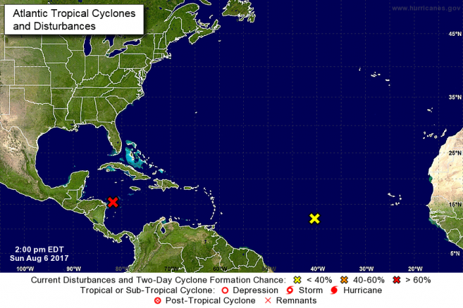
The National Emergency Management Organization (NEMO) in collaboration with the National Meteorological Service hereby informs the general public that a strong tropical wave over the west-central Caribbean Sea continues to show some signs of organization as it moves west-north westward at 10-15mph. There is a medium chance (60%) that the wave could become a tropical depression or tropical storm in the next 48 hours before it reaches Belize and the Yucatan Peninsula. The system once developed could impact anywhere from northern Belize to areas along the Yucatan Peninsula of Mexico south of Cancun.
It is forecasted that the low center will likely move over land late tomorrow into Tuesday morning. Regardless of development it will cause moderate to heavy rainfall over Belize which is likely to cause flash floods. 1-3 inches of rainfall with isolated higher amounts, gusty winds, and severe thunderstorms can be expected. Most of the rainfall is likely to affect the country late Monday evening into Tuesday morning.
• The general public is advised to start making the necessary arrangements to protect life and property. If you are at risk to bad weather conditions and flooding be prepared to move to a shelter or higher grounds, with family or friends. As a precaution start checking on family members and neighbours who are in need of assistance. Do not wait until it’s too late to take action.
• When it is raining, drivers are urged to drive with extreme caution to avoid accidents due to slippery road conditions.
NEMO emergency coordinators can be reached as follows:
I. Corozal, Mr. Williard Levy at 623-0237;
ii. Orange Walk, Ms. Suliema Celiz at 605 5046, or Mr. Aragon at 636 6094;iii. Belize District, Mr. Lionel Tillett at 6154834 and Mr. Kevin Pollard at 621 2275;
iv. San Pedro, Ms. Vanessa Parham at 632 3698;
v. Belize City, Ms. Timrose Augustine at 600 8672;
vi. Belmopan, Ms. Clare Moody at 630 9791;
vii. Cayo, Mr. Al Westby at 630 3224 or Mr. Johnny Ramclam at 625 2526;viii. Stann Creek, Mr. Keith Emmanuel at 615 9711; and
ix. Toledo, Mr. Kenton Parham at 630 9787.
x. The NEMO Emergency Hotline is 936.
The public is asked to pay attention to the official reports and advisories from the National Meteorological Service and NEMO as we continue to report on the approaching Tropical Wave.
:-End of Release:-

