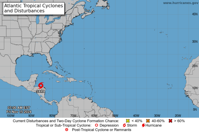
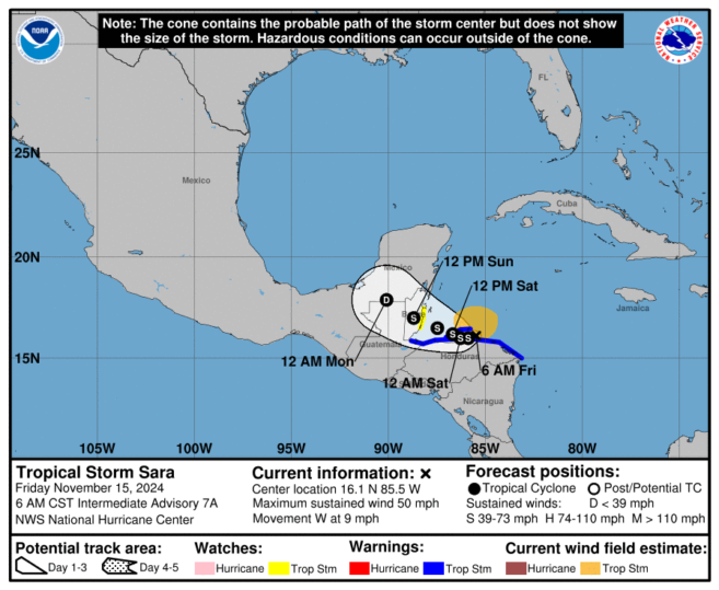
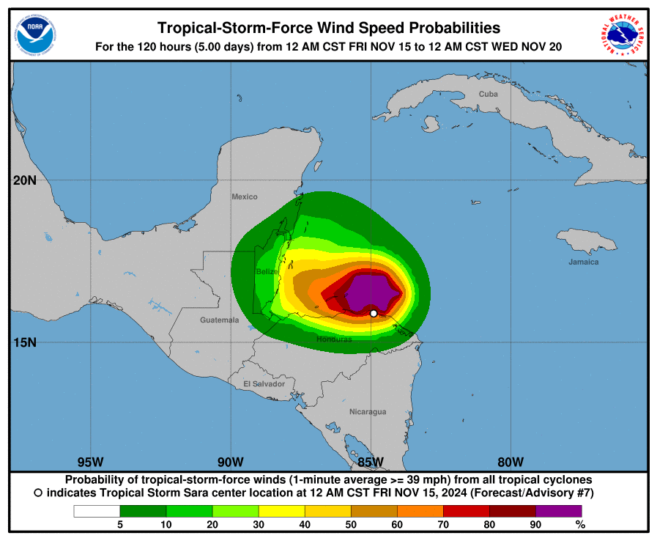
At 6 am local time, Tropical Storm Sara was located near latitude 16.1N, longitude 85.5W, or about 205 miles east-southeast of Belize City. Sara was moving to the west at 9 mph with maximum sustained winds of 50 mph. A continued westward motion at a slower forward speed is expected for the next day or two. A slow west-northwestward motion is forecast by late Saturday.
On the forecast track, the center of Sara will continue to move near the northern coast of Honduras through early on Saturday, and then approach the coast of Belize on Sunday. Some strengthening is expected, and Sara should have maximum sustained winds of around 50 mph at landfall in Belize. A tropical storm watch has been declared from Belize City southward to Placencia and this will likely be upgraded to a warning later this morning. Residents outside the watch area are advised to monitor the situation very carefully as tropical storm force winds in gusts could affect the entire country.
The main threat from this system will be heavy rainfall with totals of 5 to 10 inches with locally higher values. This is resulting in flooding. Strong, gusty winds are producing rough sea conditions. A small craft warning is currently in effect due to gusty winds near showers or thunderstorms. Mariners operating small vessels are advised to seek or remain in safe harbour and not to venture out to sea. Some coastal flooding is expected north of where the system makes landfall on Sunday. Strong winds may result in some minor damage to weak structures.
HAZARDS EXPECTED TO AFFECT BELIZE:
-Excess Rainfall – Heavy rainfall (5 – 10 inches with locally higher values), which can result in significant and life-threatening flooding.
-High Wind – Winds of up to 50 to 60 miles per hour are possible within the impact area. This may result in damage to structures, crops and trees.
-Surf – Minor coastal flooding is possible in areas of onshore flow near where the centre of the system moves inland.
FLOOD FORECAST:
-Flood Warning remains in effect for the Central and Northern Region – Rio Hondo, Macal, Mopan, and Belize Rivers. The San Roman and San Antonio Roads in the Orange Walk Districts remain flooded.
Note:
-All interests, especially those in southern Belize, MUST pay close attention and need to prepare emergency plans now.
-Persons living in areas under Flood Warning MUST remain vigilant and be prepared to implement emergency plans as necessary.
-Continue to update your family emergency plans and be prepared to put these into action. Check your emergency food, water and medical supplies in case you have to shelter in place or move to a shelter. Check on the elderly and people with disabilities, and safeguard your pets.
-Shelters in affected areas will be opened if required.
-The public is advised to continue to clear drains to reduce the risk of flooding.
Interests in the agriculture and fisheries sector are asked to monitor closely and are asked to be prepared to implement their emergency plans. Interests in the tourism sector are asked to keep visitors and guests informed of the status of TS Sara and also be prepared to implement their emergency plans.
-Business owners are asked to update their business continuity plans and to be prepared to implement them. Business owners are also being asked to assure the safety of their employees.
-All motorists are asked to drive with extreme care to avoid accidents due to slippery road conditions. Listen to advisories from NEMO for the latest on road conditions.
Residents are advised to continue monitoring this system very closely and to follow official information coming from NEMO and the Met Service. Countrywide, all NEMO district emergency operations centres remain on alert. NEMO’s hotline is 936.
NEMO reminds everyone that it is still hurricane season, and staying safe should remain a top priority. Ensure your emergency plans are up to date, stock up on essential supplies, and stay informed about weather updates from reliable sources. Let’s work together to keep our community safe and prepared.

Share
Read more
