
The National Meteorological Service of Belize continues to monitor Hurricane Eta off the coast of Nicaragua. The Category One hurricane poses no direct threat to Belize; however, heavy rainfall is expected. As of Monday, November 2nd, a small craft warning is in effect for the coastal waters. As the weather disturbance moves inland, it is forecast to reach Belize as a Tropical Depression, prompting a flood watch for the Belize, Cayo, Stann Creek, and Toledo Districts.
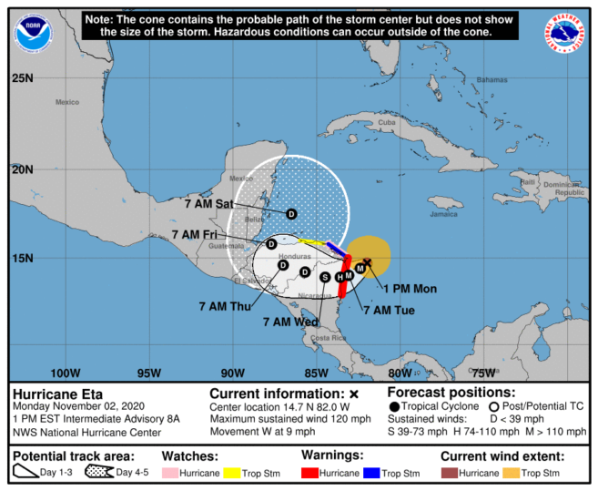 At midday today, Hurricane Eta was located about 85 miles east of Cabo Gracias on the Nicaragua/Honduras border, moving at nine miles per hour (MPH). Winds from the storm were recorded at 120 MPH. Eta is expected to approach Nicaragua’s north-eastern coast later today and make landfall within the Hurricane Warning area by tomorrow, Tuesday, November 3rd. The center of Eta is forecast to move farther inland over northern Nicaragua through Wednesday night.
 According to reports from the National Hurricane Center, hurricane-force winds extend outward up to 25 miles from the center, and tropical-storm-force winds extend outward up to 115 miles. Eta is expected to continue strengthening into a major storm before it reaches the coast of Nicaragua. As it moves inland, the hurricane will start to weaken, downgrading to a depression when the system reaches Belize.
Eta is expected to produce heavy rainfall through Friday, November 6th pouring up to 20 inches in Belize. This rainfall may lead to catastrophic, life-threatening flash flooding and river flooding, along with landslides in areas of higher terrain of Central America, like Guatemala and Honduras.
The National Meteorological Service of Belize continues to monitor this system’s progress closely, and residents are advised to be prepared and listen to official information from official sources.