
The National Meteorological Service reported on Thursday, November 13th, that damp and unstable conditions will continue to influence rainy weather over the next two days. The forecast calls for additional rain and isolated thunderstorms. As such, excessive rainfall is possible over northern, coastal, and offshore areas of the country. The National Emergency Management Organization (NEMO) has advised residents in flood-prone areas countrywide to stay alert, monitor updates, and follow official advisories.
According to the report, skies will remain mostly cloudy to overcast today, with light to moderate rain and periods of heavy showers. Rainfall is expected to pick up again tonight over northern and central regions, with a high chance of isolated thunderstorm development.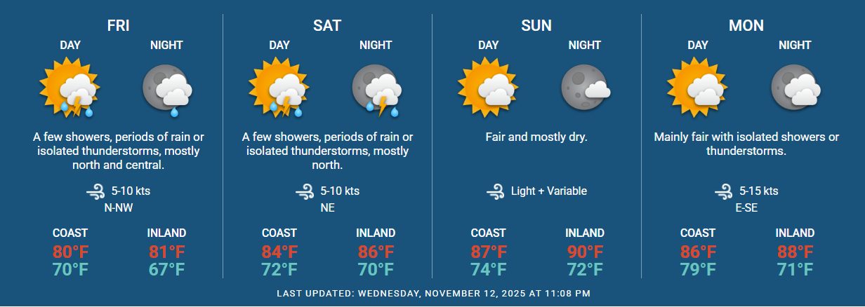
The forecast predicts continued rainfall through Friday night, as skies are expected to remain mostly cloudy with periods of rain, scattered showers, and isolated thunderstorms. The National Meteorological Service expects these weather disturbances to primarily affect the northern and central zones of the country.
Despite the overcast conditions, the tropical outlook remains calm with no cyclone formations in the North Atlantic. The weather report added that the region is expected to stay quiet for the coming days, with no tropical cyclones threatening Belize. With rainy conditions ahead, gusty winds and rough seas are possible; therefore, operators of small crafts are advised to exercise caution or remain in a safe harbour.
In San Pedro Town, Ambergris Caye, several low-lying areas in subdivisions such as San Mateo, San Pedrito, and the DFC area have experienced flooding. The local NEMO branch advises residents that if they encounter any emergency, their office can be reached at 226-4824 or 614-5865.

Share
Read more